
Google map of highway 93N, covering Lake Louise to Abraham Lake.
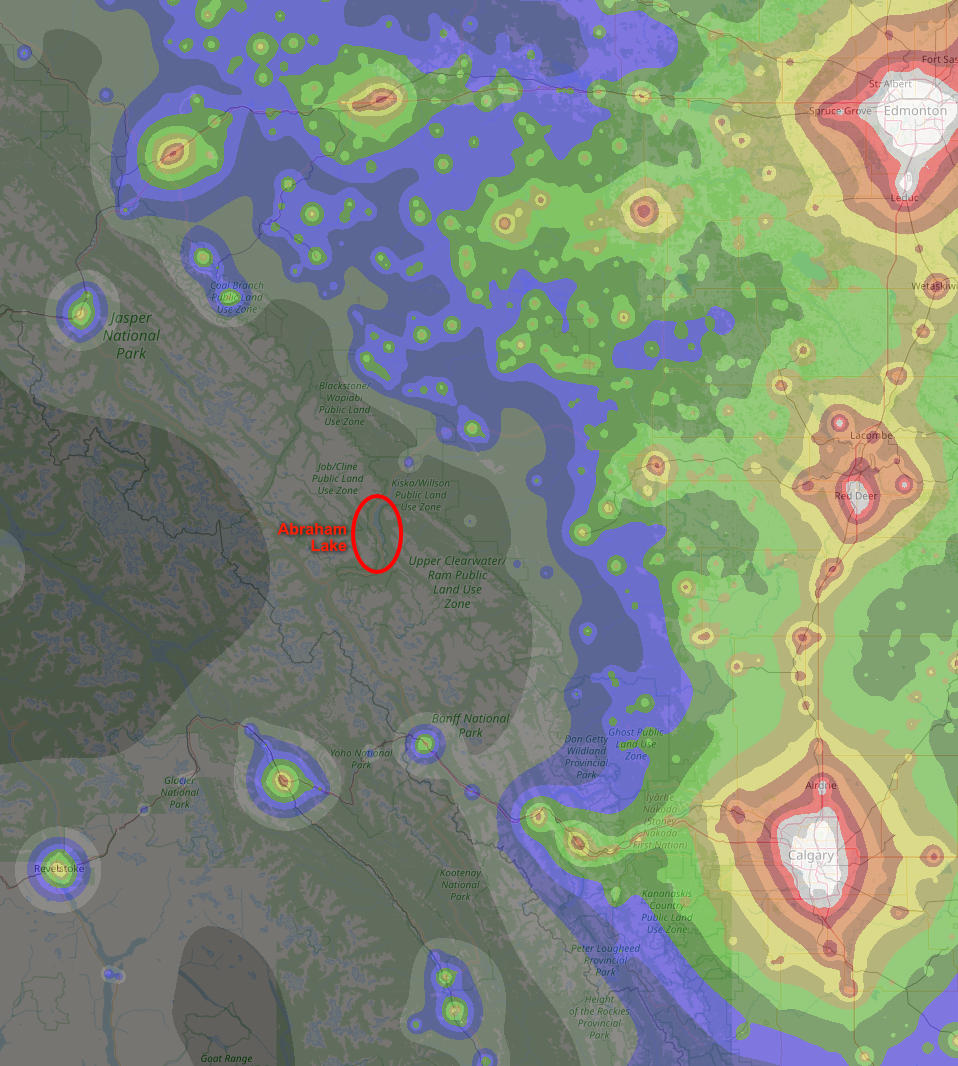
Dark sky map of western Alberta. Source: Light Pollution Atlas 2020
Here in Canada, we have plenty of dark nights in our long winters.
The winter constellation of Orion is big, bright and famous, easily visible even in the city, but it’s still a challenge to capture, for a few reasons.
Challenge #1 is the cold. The prime months for photographing Orion are November, December and January. But while those months have the longest nights, they are also the coldest months of the year. This winter November was stormy, and in late December and early January we had three weeks of -30C temperatures. While it may sound like an embrace the season activity, standing around in the dark at -30 for hours is… not fun. Not even a little bit. Cameras and batteries freeze, fingers freeze, toes freeze, lenses frost up, and the car might not start, leaving you stranded 100km from home. Just not fun.
In February and March, Orion is ideally located, high in the SW at 9pm, but the Zodiacal light – sunlight reflecting off of interplanetary dust – is so bright that it obscures Taurus. A recent accidental discovery by the Juno spacecraft is that this dust is most likely from Mars!
Challenge #2 is the moon. Well, it’s not really a challenge so much as an obstacle to night sky photography, because when it’s up the sky is too bright to capture really long exposures. So only half of each month is really dark.
Challenge #3 is the weather. The Rocky Mountains create their own clouds, and are generally unsettled and stormy during the winter, so that clear-sky windows are short and difficult to predict. However, some of the darkest skies in western Canada are in the Rocky mountains, and the scenery is spectacular, so it’s worth waiting for a window. The easiest access to really dark skies is along the beautiful highway 93N, which runs north from Lake Louise to Jasper, and along the David Thompson highway that runs west from Red Deer, following the Saskatchewan river, and then meets 93N.
Highway 93S, heading south-west from Castle Junction to Radium, also has stunning dark skies, but that’s a story for another day…

Castle Mountain, Banff National Park
Week after week of bitter cold in December 2021 was followed by a few weeks of warmer weather in January, but for most of it the sky was primarily cloudy, with only small clear patches coming through.
Finally, on the last week of January, a brief clear weather window appeared that most of the weather models seemed to agree on. The forecast at the beginning of that week looked good for Wednesday / Thursday, and the forecasts stayed consistent and good that a 12-hour clear window would appear Wednesday night.
SpotWX provides a fantastic interface to multiple weather forecast models, for any location you can drop a pin on. On Wednesday morning, January 26, the 2-day GEM-LAM forecast for 93N showed only a few low clouds in the late afternoon, clearing by 8pm. The moon was dark, the temperatures moderate, and winds were low. Perfect!
With a spectacular weather window like this, I want to see just how good “the best” optics are, so I’ve rented the big, heavy and expensive Sigma 85mm lens, which is is about the sharpest lens today. The car gets loaded up with camera gear, camping gear, dinner, breakfast, a stove, most of the warm clothes I own, and I head out to Abraham Lake for the night.
Highway 93 North, the Icefields Parkway

Crowfoot glacier

Patterson glacier, Banff National Park
This is one of the most spectacular highways in Canada, and it was a treat for me to be here by myself, with no fixed schedule, able to stop for photos anytime and anywhere. Which means that the 3-hour drive to Abraham lake took more like 5 hours…
Heading north from Lake Louise, the road passes Mt. Hector on the right and then The Pulpits – a series of sub-peaks north of Waputik Peak – on the left, both of which are popular places for backcountry skiing. Then past Hector Lake, past Crowfoot Peak and Bow Lake, up over Bow Summit and past Peyto Lake – all beautiful, worthy destinations any time of the year.

Mt Patterson, Banff National Park

Mt Chephren, Banff National Park
After Bow Summit, and locally famous Peyto Lake, the highway descends dramatically, passing Mt Patterson, then Howse Peak, then Mt. Chephren and Chephren Lake, before meeting the Saskatchewan river at the unsurprisingly named Saskatchewan River Crossing.
The Saskatchewan River drains four icefields along the spine of the Rocky Mountains: the Lyell Icefield, 20km to the west, the SW portion of the Columbia Icefield via the Saskatchewan glacier, 35km NW, the Mons Icefield, 20km west, and the Freshfield Icefield, 30km SW. That’s a big area with heavy snowfall, so already at Saskatchewan Crossing it’s a fairly substantial river.

NE face of Chephren

Mt. Wilson
Being late in the afternoon, all the dramatic glaciated peaks on the west of the highway are shaded, but Mt Wilson, towering over Saskatchewan Crossing on the NE side, is still basking beautifully in the low light of the setting sun.

Sunset on David Thompson highway
The plan was to get to Abraham Lake before dark, in order to explore the area a bit and scope out a good location for night photos, but whoops, too many photo stops along the way make a mockery of that plan. I just manage to get to Preachers Point, at the southern end of the lake, by twilight.
Abraham Lake
Abraham lake is a 30km long reservoir on the Saskatchewan river. It’s locally famous for the methane bubbles that form in the winter ice due to decomposing vegetation, as well as for being swept clear of snow by cold winds blowing through the valley from the west, revealing the bubbles and making for good ice skating.

First stars over Abraham Lake
Tonight, however, no skating was done, no bubbles were photographed, and no strong winds were blowing. Still windy enough, though, that I look for a reasonably sheltered location on the shore to set up the camera and star tracker, behind a dense clump of trees.
By around 6:30 there are still low clouds above the mountains to the south, and the first stars are appearing in the twilight sky. Fortunately the clouds are dissipating, exactly as forecast, and are mostly gone by 7:30 when the last glimmer of twilight fades and the sky becomes fully dark. The weather forecast was exactly right!
And what beautiful darkness there is here! The nearest town of any size is Nordegg, almost 50km north-east, but to the south, where Orion is, Lake Louise is about 80km, Banff and Canmore are over 120km, and the ridiculously bright city of Calgary is close to 200km away. This is excellent darkness, class 1 or 2 on the Bortle scale, almost as good as it gets.
Orion over Abraham Lake
Orion rising over Abraham lake. Click here to zoom into an high-resolution annotated image.
It takes about an hour to capture the 45 or so frames that get stitched together to create this mosaic image. For you photography types: the Sigma lens is amazingly sharp, and I’m able to shoot at f/2.0, which allows for shorter exposure times than normal. Each frame was exposed for 60 seconds, at ISO 800 and f/2.0.
The camera is on a motorized drive that tracks the rotation of the Earth, but for the ground frames that drive is stopped. All the time that the camera is capturing distant photons, I’m just in awe of the glorious night sky! Not quite enough awe to overcome the cold that creeps into my feet and fingers, but doing lunges and other exercises while the camera works helps a lot with that.
The resulting image covers about 70×50 degrees and includes the brightest star in the sky, two of the closest star clusters to Earth, numerous red nebulae including the Orion Nebula, which is the closest star-forming region, over a dozen bright star clusters, and millions of stars.
The rich swath of the Milky Way fills the left side of the image and contains numerous dark galactic cloud bands and star clusters. Orion, centre-right in the image, is just off the galactic plane, with the prominent V-shape of Taurus above Orion, followed by the brilliant Pleiades cluster at upper-right.
Orion is perhaps the most easily recognized constellation in the sky, and for good reason. Its main stars are very bright, and the constellation actually looks like something. Numerous cultures for 1000s of years have seen these stars and imagined a celestial hunter in the winter night sky.
Sirius, the brightest star in the sky, is just above the horizon, visible through the gap between Normandy and Ardenness Peaks (on the right) and the Mt William Booth massif on the left, and is reflecting beautifully in the lake ice. The sky is rotating quite quickly, but I’m able to capture this reflection in the few minutes before Sirius moves to the right and disappears behind the mountain.
There are an incredible variety of stunning deep-sky objects in this part of the night sky; well worth a deep dive into this image to explore this rich corner of our galaxy.
Morning light

Morning light on the wind-carved lower slopes of Crowfoot Peak.
Crowfoot Peak in the morning
Crowfoot Peak detail in the morning
After staying up until almost 2am photographing the glorious sky, there was no way I was going to drive three hours back home, so I slept for a few hours in the car – a cold and miserable experience! – but was then able to enjoy the soft light of dawn on the Icefields parkway.
After having spent so many hours in the darkness, in awe of the uncountable stars, seeing the sun rise again triggers a strange feeling of displacement – the day and night feel like different worlds. And in a sense they are, because in the darkness the starry sky completely dominates the view and senses, while in the daytime it’s all about the landscape – this planet!
Bow Lake and Crowfoot peak were especially stunning in the morning light, and I spend several sleep-deprived but happy hours going for a little ski, feeling the warmth of the sun in the -20 air, and capturing the morning light on the peaks before heading to Lake Louise for breakfast.
To wild places and magical skies!
– Darren Foltinek, February 2022